90km
7 days, 6 nights
Queensland
April 2024
Just off the coast of Maryborough lies the ancient paradise of K’Gari (formerly known as Fraser Island). At 123km long, K’Gari is the world’s largest sand island and is recognised as a World Heritage Area (Queensland Government, 2025). Forming part of the Great Sandy National Park, K’Gari is the traditional country of the Butchulla people who are known to have lived on and preserved K’Gari for at least 5000 years (although the true age is likely to be much older) (Queensland Government, 2025).
K’Gari is famous for untouched white beaches, crystal inland lakes, wild rainforest, ancient sand dunes and mystic wongari (dingoes). K’Gari is unlike anywhere else I have travelled and holds an ethereal feel, seemingly blurring the line between modern and ancient. There is a strong sense of the eternal connection of the Butchulla people to K’Gari, and I pay my respect for our time spent on Butchulla country. The Butchulla people have the deepest of roots on K’Gari and have continued connection despite dispossession of land and culture, where many Butchulla people were forcibly removed from K’Gari through European settlement in the 1840s (Queensland Government, 2025). Like the Butchulla people, K’Gari is enormously resilient and has largely recovered from active mining, logging and agricultural industries in the 19th and 20th centuries (Queensland Government, 2025).
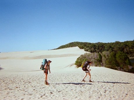
K’Gari Great Walk is one of the best multi-day hikes I’ve faced yet. It’s a special combination of epic nature, adventure and unmatched beauty. This is an intermediate walk, but with the additional challenges of navigating wongari and remoteness of the hike. It brings unique and exciting challenges, but I’d suggest it is best for punters with some bushwalking experience.
What’s Ahead:
Click the links to jump ahead:
- Getting to and from the Trail
- Planned Route
- Navigation & Safety
- Campsites
- Wongari & Wildlife
- Conditions & Terrain
- Packing List
- Day 1: Wanggoolba Creek to Lake Boomanjin
- Day 2: Lake Boomanjin to Central Station
- Day 3: Central Station to Lake Boorangoora
- Day 4: Lake Boorangoora to Lake Wabby
- Day 5: Lake Wabby to the Valley of the Giants
- Day 6: Valley of the Giants to Lake Garawongera
- Day 7: Lake Garawongera to Happy Valley
- Day 8: Final Hurrah & Heading Home
- Reflections: Peaks & Pits
Getting to and from the Trail
GETTING TO THE TRAIL:
There are a few options for getting to K’Gari including by 4WD via the ferry, on foot via the ferry, by plane, private boat or commercial tour. More detailed information on these options is available here.
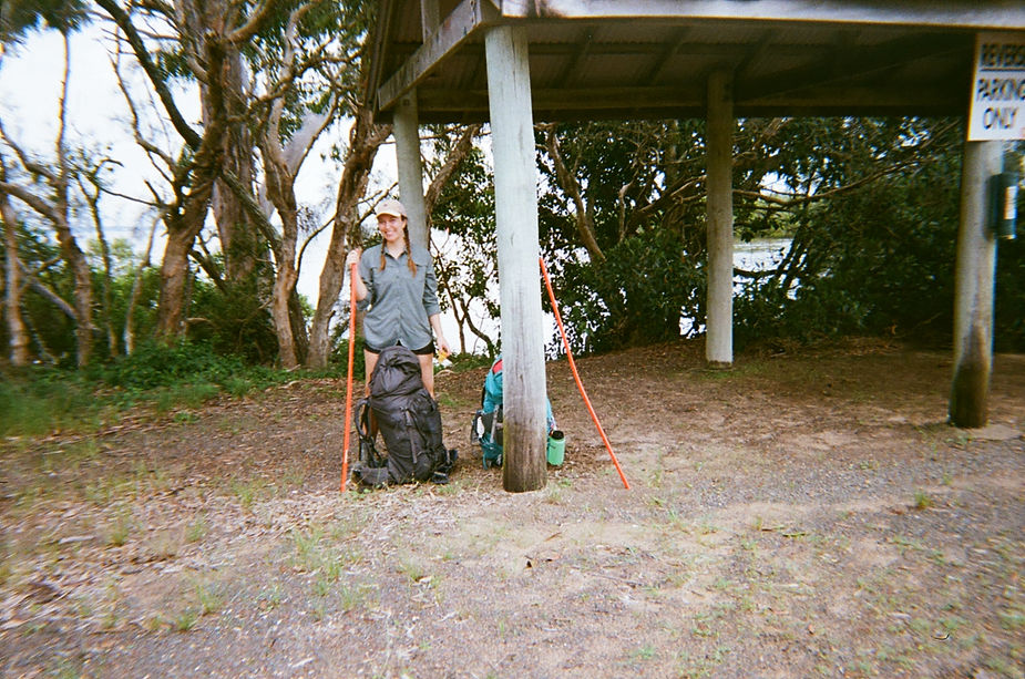
For our adventure, we weighed up the option of taking a 4WD but ran into questions about how we would get from the end of the track back to the car, and whether we could safely leave the car for a week. We were worried about the old Suzuki’s clearance and it all felt a little too stressful. So we pivoted to going on foot and taking the ferry.
Mantaray Barges and Sea Link are the operators of the Inskip Point and River Heads ferries respectively. The ferries leave the mainland from two points; Inskip Point (Rainbow Beach) which will take you to the southern end of the Island, and River Heads (Maryborough) which will take you to the Western side of the island. The Inskip ferry will drop you at Hook Point right at the South of the Island, and you will need to either get a 4WD taxi or walk the 25.3km to the start of the walk at Dilli Village.
As we were staying in Hervey Bay, we opted to take the Sea Link ferry from River Heads to Wanggoolba Creek. There is ample parking at River Heads and no time limit so we were able to leave the car for the whole week (note there is no security in the carpark and it’s open access so not sure how safe this is – but we did let the ferry office know to expect our car there for the week). Once we arrived at Wanggoolba Creek, we started walking via the road and then an access track to Lake Boomanjin. We got lost several times, and I’m not sure how, but our mistakes cost us about an extra 10km in walking. There is an actual walking track that connects Wanggoolba Creek to Lake Boomanjin and it should theoretically be 14.5km if you don’t get lost. Information on the Wanggoolba Walk is available here.
You will need to pre-purchase any ferry tickets which can be done over the phone. Make sure you are aware of the check-in and boarding time and show-up early because they are prompt with leaving on schedule. Ticket information for Sea Link can be found here. Tickets were around $45 per person.
GETTING HOME:
After completing our walk in Happy Valley, we stayed one night before heading back to Brisbane. We took a 4WD taxi from our accommodation at Happy Valley to the ferry barge at Kingfisher Resort. This was so fun and I can’t recommend it enough! It’s about an hour drive along the beach and access tracks depending on weather and the tides. This showed us another whole side to K’Gari compared to all that we’d seen while walking the trail. The vastness and wildness of the beach fell in stark contrast to the intimacy of walking amongst the trees and birdsong. This might be a bit rough if you tend to get carsick, but the drive was so much fun. The driver was really friendly, genuine and informative, sharing stories about his life on K’Gari and some of the worst cases of bogged 4WDs he’d seen. The taxi cost us a couple of hundred dollars but was really worth it. If you’re planning to take the taxi, make sure you book it nice and early because it’s the only taxi on the island and if it’s booked out because of an event, you’ll be hard pressed to get other transport. You can book the Fraser Island Taxi Service by email or phone: 0429 379 188 / admin@fraserservice.com.au
The taxi dropped us off at Kingfisher Resort where we enjoyed a couple of beers and a swim in the pristine water before catching our ferry. This was pretty incredible and felt very luxurious after our days in the bush so I would definitely suggest getting a later ferry and making sure you have some time at the resort before you head home. It’s free for you to access the beach, and there are a couple of cafes/restaurants.
We eventually took another SeaLink ferry back to River Heads. This is a really beautiful way to end the trip, and the captain actually gave us a tour of the driving room (is there a proper name for this?) and we got to steer the ship and pull the horn!
Planned Route
The walk can be done in either direction, but we opted to walk from South to North. I’d recommend this because finishing in Happy Valley is pretty cool, there’s lots of accommodation options and a bar. It also meant that on our last day we got to take the 4WD taxi back to the ferry which was a highlight!
If you look at the QLD government websites or other blogs you’ll notice that most start from Dilli Village. As we were staying in Hervey Bay prior to the walk, it was easiest to get the ferry from River Heads. This limited our options for starting the walk and took some extra planning, but we landed on taking the ferry from River Head to Wanggoolba Creek, and then walking to Boomanjin. This meant that we didn’t follow the complete Great Walk which starts in Dilli Village. As you will see in Day 1, this was supposed to be a fairly straight forward route of only 17km, however due to getting lost twice, ended up being closer to 26km. This route was ok as a work-around, but if you can, it’s probably easiest to just start from Dilli Village. However, good to know there are other options if this doesn’t suit.
| Journey | Distance By Map | Distance by Measurement (Garmin watch) | |
| Day 1 | River Heads to Wanggoolba Creek (by ferry) Wanggoolba Creek to Lake Boomanjin | 14.5km | 26.3km |
| Day 2 | Lake Boomanjin to Central Station | 14.7km | 16.4km |
| Day 3 | Central Station to Lake Boorangoora | 6.6km | 7.7km |
| Day 4 | Lake Boorangoora to Lake Wabby | 12km | 12.6km |
| Day 5 | Lake Wabby to Valley of the Giants | 16.1km | 18.8km (including side quest) |
| Day 6 | Valley of the Giants to Lake Garawongera | 13.1km | 18km (including side quest) |
| Day 7 | Lake Garawongera to Happy Valley | 6.7km | 6.6km |
| Day 8 | Happy Valley to Kingfisher Bay Resort (4wd taxi) Kingfisher Bay Resort to River Heads (Ferry) |
Navigation & Safety:
Navigation on the K’Gari Great Walk is straight-forward and well-signed for the most part. However, I’d still recommend taking a compass and a few map options in case you come into any issues. The walk is pretty remote and we only passed a couple of other people the whole walk, so it’s important that you are prepared with a Personal Locator Beacon (PLB), first aid kit, map and compass just in case.
We purchased a map from a hiking shop in Brisbane which we liked because it is larger and more detailed. You can find retailers that sell the map here. We also printed these maps:
I’d also recommend printing an up-to-date copy of the K’Gari Conditions Report which has important information about Dingo safety, tide times and park alerts.
With K’Gari being so remote, it’s like a small town where most of the locals know each other. We realised this when we passed a police car at a rare interval where the walking track intersected with the 4WD track. The police officer came over to speak with us, asked us where we were going, when we expected to arrive and where we were staying in Happy Valley. We gave the name of the accommodation and the taxi driver who was taking us back to the ferry, and told him about a scary dingo interaction. Suddenly, a 4WD started coming down the track, and the officer quickly climbed into his 4WD before flicking his red and blue lights, and pulling the car over for a breatho – we thought nothing more of it. When we eventually made it to our taxi a few days later, the driver mentioned that the police officer had called him to check we’d made it to Happy Valley. When we called the Rangers to report an interaction with a dingo, the ranger said he’d heard from the police officer that there’d been an incident and the rangers were already investigating. So someone was kindly keeping an eye out for us and information moves like wildfire!
All the same, make sure you have an emergency contact who knows when to expect you home and complete the Remote Bushwalking Advice Form. This is really important so that rangers can locate you if they need to do so (i.e. concerns for your welfare or need to evacuate due to bush fire). Make sure you walk in groups and take a PLB to call for help in an emergency if you have no phone reception. These can be really expensive to purchase, but you can easily hire one from a local hiking shop and they are pretty affordable for hire. There is some more safety information on walking available here.
Campsites:
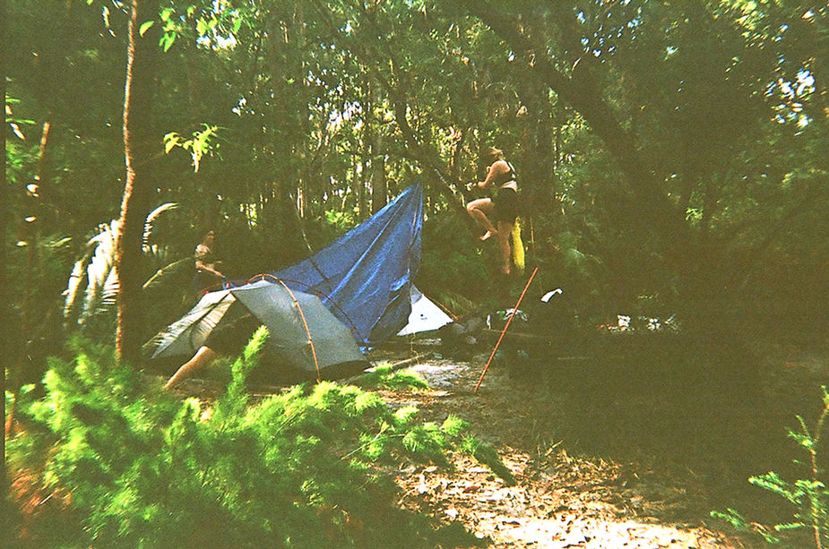
The campsites on this walk are well-managed. All campsites have composting toilets, a platform and dingo boxes. There is only one dingo box per site, so if you are a group of more than 2, you will struggle to fit everything into a dingo box. Ultimately, as long as all the food and rubbish makes it into the dingo box you should be ok, but as the campsites were really empty when we were there, we got to use one dingo box per pair. This meant we could store our packs along with all our food every night, and had no worries when we heard dingoes coming up to the tents for a sticky-beak after we had gone to bed. It’s good to be aware that most of the campsites are unfenced, and you will need to be mindful of the dingoes while at camp. This wasn’t a problem and shouldn’t be a deterrent, but just something to be aware of – particularly when cooking dinner!
You can find all the information about campsites here. You will need to book each campsite, and they are fairly low-cost. We comfortably fit two 2-man tents at each site. There was plenty of water in the tank at each site, but there had been a lot of recent rain so check the national park alerts before starting walking. There is no tank water available between campsites.
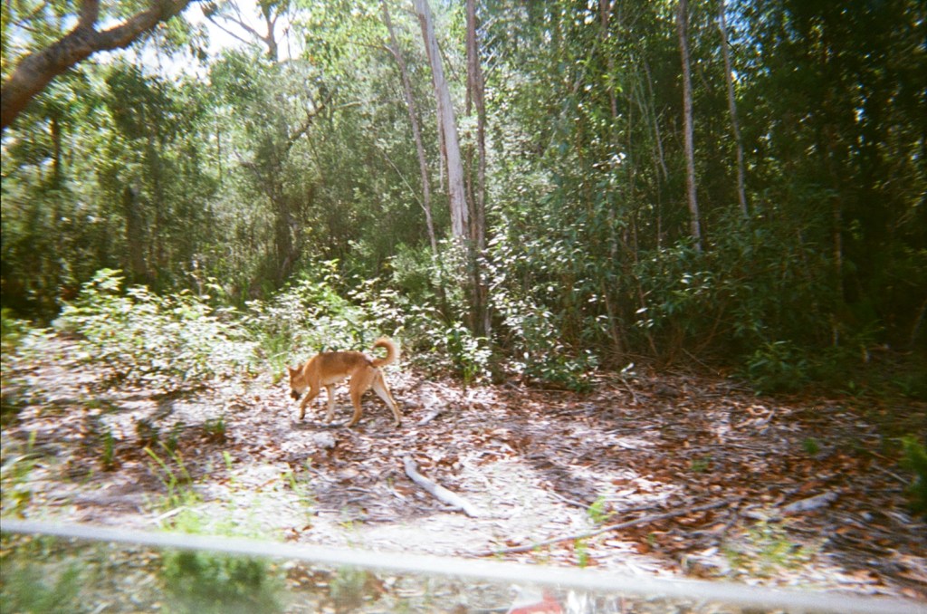
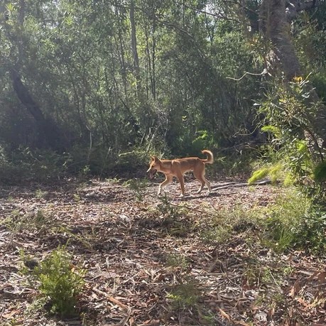
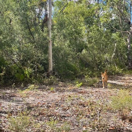
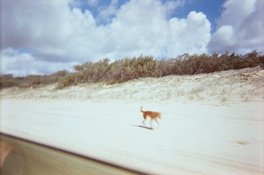
Wongari & Wildlife:
Wongari or dingos are a native species that are protected wildlife in Queensland. On K’Gari, wongari are usually a golden sandy colour and are about the size of a medium domestic dog (Queensland Government, 2024). Many of the wongari have a coloured tag in their ear for tracking and conservation/management purposes.
The wongari are one of the incredible features that makes K’Gari so unique, and seeing dingoes in the wild has been one of the more special experiences I’ve had bush walking. In saying that, wongari aren’t to be trifled with and it’s important to remember that they are wild animals and very much traverse the island in active packs. The dingoes on K’Gari have gotten plenty of media attention for several attacks on children and visitors. While this might be caused by a range of factors, there are some clear guidelines on K’Gari around managing food and keeping children nearby to minimise any risk. Unfortunately, we often saw kids unattended and food left around, and it felt like there was a lot of potential for something to go wrong. There are some fenced-in areas around the island where visitors can have picnics (not many of these are on the walk), and at campsites you will find dingo boxes to store your food. The rangers also told us that the dingoes will sometimes be interested in your shoes and socks after they get a bit smelly so store them in the boxes as well if you have space!
We had several interactions with wongari during our trip, and one in particular which left us feeling uneasy. We were there in April which is mating season, a time where wongari are using dominance testing and protecting territory. At the end of our walk we reported the experience to one of the rangers. The ranger asked lots of questions about the interaction and advised us that they would use the information to assess the safety of that particular dingo (we were able to recall the number on its ear tag). As it turned out, this was a notorious dingo who was already on the watchlist! If you need to report any wongari interactions to the rangers, you can contact them on 07 4217 9150 / dingo.ranger@detsi.qld.gov.au
If you’re travelling to K’Gari, it’s worth reading the guidelines both to minimise your impact on the dingoes and understand how to manage any interactions you might have with them (we found making yourself big, loud and assertive was the key, as well as having a stick handy to keep distance if a dingo approaches). This is a beautiful resource about the wongari, including a short section by Butchulla man Conway Burns describing the significance and history of dingoes for the Butchulla people.
Make sure you read all the resources on how to be Dingo-Safe. I really strongly recommend reading this article on how to react if a dingo approaches you, as in our experience, the dominance-testing went on for several minutes before the dingoes eventually passed us. They startled us after we suddenly came around a corner, and we felt unsure of how to act in the moment and I wish we had read some more of the literature beforehand as it was a pretty unsettling experience.
Other than the wongari, there is incredible wildlife on K’Gari from birds to snakes, sharks, goannas, wallabies, butterflies and catfish. Due to the soft sand, you can often see tracks so make sure you read up on your tracks and scats before the trip!
Conditions & Terrain:
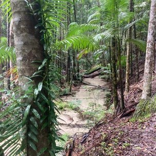
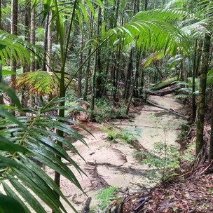
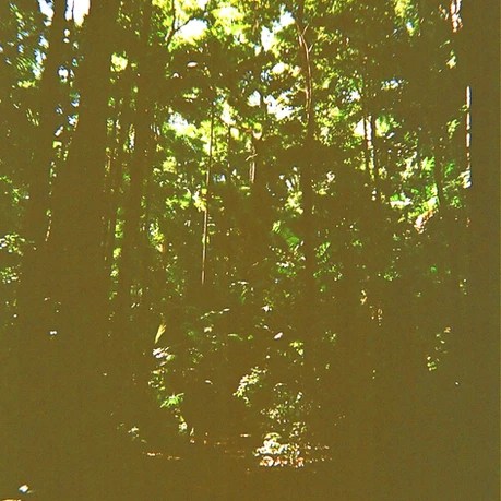
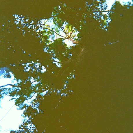
The track is pretty standard bush-walking track most of the way, mainly on dirt and some soft sand. There were very few really soft sand sections, and even though there had been a lot of rain, there was very little mud. There are sections of the track that are exposed such as day 2, but a lot of walking is under the bush or rainforest canopy. This makes for a rich tick and leech environment, so make sure you are prepared for this.
Packing List:
For a 7 day hike, our bags usually weigh close to 20kg. We took some more luxury items on this trip like the tarp and ropes, as well as a bottle of rum which was so appreciated on the rainy nights! For us the extra weight is worth the comfort of these items, but you’ll have to weigh up your options and consider whether it’s worth it. There are lots of opportunities for swimming on this trip and we all swam in our shorts/undies rather than swimming in bathers, and the microfibre towel was a good addition. The weather can be unpredictable as you’re walking on an island, but for the most part the weather was very mild in April and wasn’t too cold overnight.
| GEAR: Hiking pack (60-70L) Dry bags Water bladder/drink bottles (at least 2L) Waterproof pack cover Sleeping bag Sleeping mat Sleeping bag liner Tent Headtorch + batteries Electrical tape Shovel Microfibre towel Map Compass Ropes | FIRST AID & SAFETY: Personal Location Beacon (PLB) Bug repellent Snake bite bandage Bandaids Blister kits Hand sanitiser Pain killers/Analgesia Antihistamine Sports tape Tweezers Scissors Antiseptic cream Alcohol wipes |
| COOKING: Tea towe lWashing up liquid and sponge Gas stove and cookwear Gas/butane canister Matches/lighter Cup/mug Spork Plate/bowl Sharp knife Chopping board Garbage bag | CLOTHING: Hiking shirt Hiking pants/shorts Thermal top and bottom T shirt for campPants for camp Fleece Rain jacket/poncho 2x sports bra 2x hiking socks 1x camp socks Hiking boots/trail runners Camp shoes (crocs/sandals) Hat Sunnies |
| TOILETRIES: Toothbrush Toothpaste Hairbrush Sunscreen Hand sanitiser Toilet paper Vasoline (as lip balm and to help with chaffing) | OPTIONAL: Tarp/ropes Walking poles Book Camera Binoculars Art supplies Bathers/swimmers Pillow Power bank Face wash and moisturiser |
Day 1: Wanggoolba Creek to Lake Boomanjin
Distance: 26.3km
Duration: 8hours
The day started out early with a short roadtrip from our accommodation in Hervey Bay to the River Heads Ferry Terminal. We parked in the carpark before checking in at the SeaLink office and boarded the ferry around 8:30AM for a prompt send-off at 9:00AM. The ferry is such a fun start to the journey, with excitement and some anxiety starting to bubble as we got closer and closer to the island. After about 45 minutes we came to the Wanggoolba Creek ferry barge.
As we prepared to disembark, a fluoro crew member handed us each a bright orange PVC pipe and said “here are your dingo wackers just in case”. This crew member seemed like the type of character who might keep a few neon PVC pipes on board to trick unsuspecting hikers into carrying a ridiculous neon stick around for a week. Laughing as if we were playing along, we tried to give the sticks back but he was very adamant that we take them just in case, and explained that they are used to keep distance between between yourself and the dingo. We stepped off the ferry each with an orange stick in hand, and felt a little uneasy as the ferry pulled away with all the tourists destined for Kingfisher Resort.
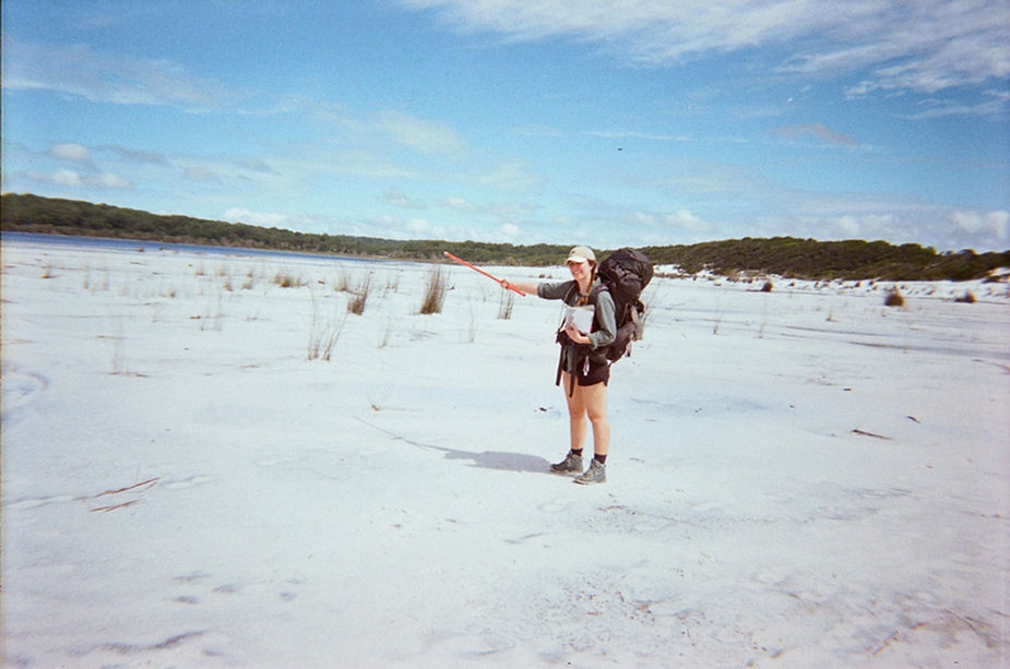
Nevertheless, we had made it to the island and there were just 14.5km between us and a beautiful camp! We started walking around 10AM and it was pretty hot at this point, with most of the first day very exposed. We came across a map but we quickly became confused about which trail to take and started walking along the road with the view of later cutting in via a fire access route. Don’t ask me what we did wrong, but we got lost. As it turned out, we missed the turn off onto the trail not once, but twice! Suddenly we were adding unexpected km’s to our day and having to make decisions about whether to continue on or turn back to find the correct trail. We decided not to turn back, and at this point the stress was starting to kick in as it dawned on us that it would be difficult to get to camp long before dark.
By some miracle we managed to make it to camp without getting lost a third time. We had made it to Lake Boomanjin which is the largest perched lake in the word (Queensland Government, 2023). We picked a prime camp spot inside the dingo fence and set-up camp before heading down to Lake Boomanjin for a swim. The lake is only a couple of hundred meters from the campsite. This was an incredible spot with tannin water and stunning birdlife. The campsite and lake were completely empty and it was pretty amazing to have this magical spot to ourselves. We then headed back to camp, hung up our wet clothes and had a nice hot dinner before heading to bed when the torrential rain started.
Boomanjin Campsite:
This is a fenced in campsite next to a day-use area with water and toilets including a flushing toilet (pretty serious luxury). The dingo fence is a bit strange, and felt somewhat reminiscent of a scene from Jurassic Park. There were no other campers and so plenty of dingo boxes were available for use. The campsite has a platform for each site where we sat and cooked our dinner. The campsite is well-shaded and it gets dark early because of the trees.
Peaks and Pits:
PEAK: The ferry and swimming at Lake Boomanjin.
PIT: The unexpected additional 10+km and lots of road walking.
Day 2: Lake Boomanjin to Central Station
Distance: 16.4km
Duration: 6hours
We woke up late, still sore and recovering from the long kilometers the day before. You can imagine our surprise when we woke to find something had been eating our clothes overnight! We had a slow start before starting the journey to Central Station. We were meeting with friends at Central Station who were a day behind us and were walking straight from Wanggoolba to Central Station (9.5km).
The track starts off fairly sandy with closed-in shrub encompassing the path. After only about 15minutes walking, we rounded a corner only to come face to face with two dingoes. Honestly, we found the experience a little bit unsettling because the dingoes immediately approached us and were very inquisitive. We held our dingo sticks out and the dingoes tried to get around the sticks, before they started to growl at us and then howl. This stand off went on for several minutes with us unsure of what to do next, before we eventually decided to take a step back wards to clear the path and the dingoes walked past us. We took notes of the tags on their ears which we later reported to the rangers and found out the male dingo is a bit notorious for testing visitors.
After this, we quickly kept moving and progressed through a large sandy section which is very exposed (with some regular checks over the shoulder for our canine friends). The soft sand was short-lived before heading off onto a bushy track and the remaining trek was mostly hidden under rainforest canopy. At about midway we came across Lake Benaroon where we stopped for a quick dip and a lunch break. The final section of the walk is mostly through tall Kauri pines before the trail leads into Central Station. As we approach the campsite, we crossed the 4WD tracks and the area seemed pretty busy for non-hiking campers. We quickly found our friends, celebrated our reunion and excitedly spoke of our adventures for the day over a hot dinner and a cup of tea.
Central Station Campsite:
The campsite was again very quiet, although there were a few more people around than Lake Boomanjin. The rainforest at Central Station is thick, and the chorus of birdsong is incredible as we watched the golden afternoon sun stream through the leaves and eventually dim out. The campsite is partially fenced in, and has plenty of platforms and animal-proof boxes, as well as composting toilets. The 4WD accessible campsite is not far away and there are reportedly hot showers (for a $2 coin). There were lots and lots of march flies and mosquitos! While these were pratty bad at most camp sites, they were particularly bad here and you’ll really want some insect repellant.
Peaks & Pits:
PEAK: Seeing dingoes up so close and then reuniting with our friends!
PIT: Being scared after our dingo interaction and checking behind us for the rest of the day.
Day 3: Central Station to Lake Boorangoora
Distance: 7.7km
Duration: 2.5hours
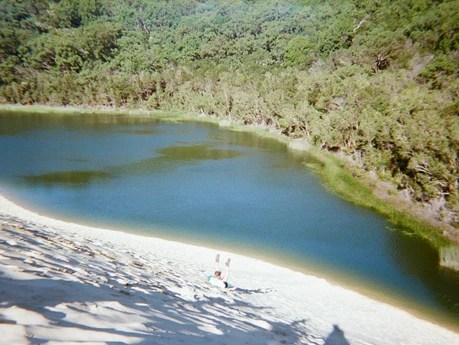
Day 3 has some choose your own adventure options. You get to Lake Boorangoora either via Basin Lake (6.6km) or via Pine Valley (11.3km). We opted for Basin Lake, but first things first, we headed over to the boardwalk to check out the pristine creek. The creek is so incredibly clear that it’s hard to see the water moving! We then travelled along the boardwalk before starting a short but steep climb up the sandhill surrounded by scrub and scribbly gum before emerging at the shores of Basin Lake. The lake is pretty stunner, with tannin-stained water and reeds, all surrounded by endless bush that helps create a green effect to the water. We took a long break for a swim, lunch and a nap before continuing on to Lake Boorangoora.
We were all minding our own business as we walked through the bush when suddenly, I briefly looked up and noticed a dark shape on the walker in front’s shoulder, emerging from under their hat. I watched as the biggest spider I have ever seen emerged from over the shoulder of my walking mate, and proceeded to extend long spindly legs towards the brain of the hiking pack. Struck and desperate for words, I could only dramatically mutter ‘I’m sorry’, and watched as my walking mate had the fear of death in their eyes, clueless about the cause of concern. Fortunately, a fellow quickly whacked it off with a pole and the hiker lived to walk another day, but a new fear was unlocked that day of spiders hiding under legionnaires hats.
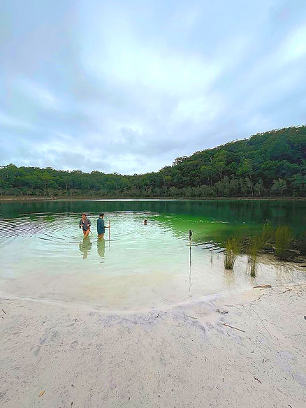
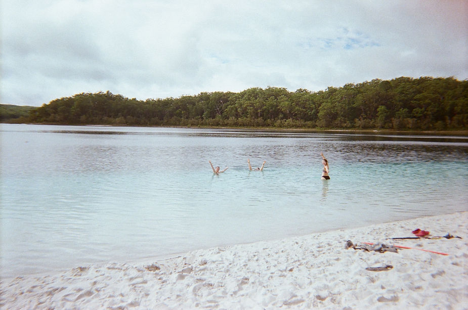
We eventually came upon Lake Boorangoora (formerly known as Lake McKenzie). This spot is an incredible natural marvel. The whiteness of the sand and the two-tone blue of the water is amazing. Swimming in the freshwater was so refreshing and the views are almost other-worldly.
Boorangoora Campsite:
The campsite is only a few hundred meters from the lake and is separate to the day-use area. The campsite is fenced in, and dingo boxes and platforms are available. It’s a bit of a walk to the toilets and tank water. It unfortunately rained the night and we were very glad to have had a tarp to have a dry space we could all sit under to chat, play cards and have some dinner.
Peaks & Pits:
PEAK: 2 incredible swims at Basin Lake and Lake Boorangoora.
PIT: Coming eye to multiple eyes with the larges spider in the known universe.
Day 4: Lake Boorangoora to Lake Wabby
Distance: 12.6km
Duration: 4.25hours
The trail winds through bush and tall rainforests before the views open into incredible sand dunes and the Hammerstone Sandblow. At the bottom of the dune lies Lake Wabby, which is the deepest lake on the island, and is an incredible emerald green against the yellow sand of the dunes. Lake Wabby was formed by migrating sands which eventually cut off a coastal creek, creating the lake (Queensland Government, 2023). Half the group decided to stay at the top, while half found their way down to the shores of Lake Wabby where catfish lurked along the shoreline.
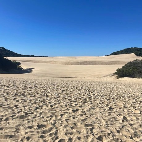
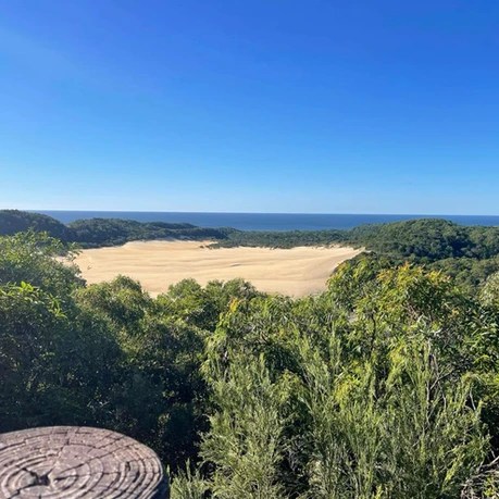
From Lake Wabby, it is a short climb up to the lookout which oversees views of Lake Wabby and Hammerstone Sandblow, with the ocean visible in the background. Due to the constant migration of the exposed sands, this view is ever-changing as winds blow more and more sand into Lake Wabby, reclaiming sandy territory (Queensland Government, 2023).
After a bit of a climb up to the campsite, we chose our spot for the night. We had arrived early enough to enjoy the last couple of hours of sunshine, and we saw a beautiful goanna sunning itself up in a tree. This was one of my favourite campsites on the trip, and really enjoyed the beautiful bush that surrounded camp.
Lake Wabby Campsite:
Like the others, this campsite has toilets, water tank, platforms and dingo boxes. It was a short up-hill walk to get to the toilets which felt a bit rude after a day’s walking, but also a nice stretch (although this might be annoying in bad weather). Near the toilets is another lookout and a few day visitors passed after checking out the view. This campsite seems to be a bit of a hotspot for dingoes, we saw dingoes on 2 occasions at this campsite (not sure if it was the same one). The dingo was definitely inquisitive and actually came quite close while we were cooking dinner. There was also some suspicious sniffing and breathing around the tents once we were in bed.
Peaks & Pits:
PEAK: Catfish spotting at Lake Wabby.
PIT: The endless climb back up that sand dune.
Day 5: Lake Wabby to the Valley of the Giants
Distance: 18.8km (including side quest)
Duration: 6hours
We started off again checking out the sandblow before reconnecting with the track. You will see the Badjala Sandblow lookout which is only another 600m each way, before continuing into open forest and eventually rainforest canopy. The trail starts with some climbing before eventually making a slow descent into the Valley of the Giants. It was along this stretch that we entered what we fondly refer to as the Valley of the Leeches. The leeches were everywhere and extremely persistent! We were glad to have a tarp to lay down which we could sit on during breaks, as otherwise we would have needed to continue standing and fighting off leeches climbing up our boots.
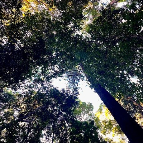
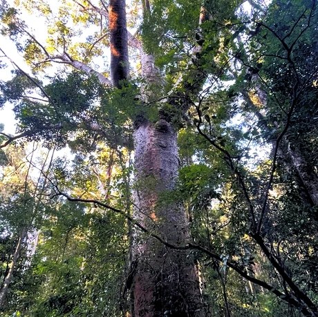
The trees seem to get taller and taller as you approach the Valley of the Giants, and the immensity of the canopy above is awe-inspiring. There are some opportunities to choose your own adventure on this day, with the option of visiting the Giant Satinay. While we did not visit the Giant Satinay, half the team took the optional trip to the Giant Tallowwood for only an extra 1.3km each way. The Giant Tallowwood is believed to be more than 1000 years old (Queensland Government, 2023).
After arriving at camp, we quickly set-up, mindful that we were quickly losing daylight under the thick canopy. The youngest and probably tastiest in our group piqued the interest of a dingo when she went down to the bathroom, and so we were a little more on high alert throughout the evening. So much so, that later that evening when we were cooking dinner, we all turned to the sudden sound of rustling in the fallen leaves and started yelling into the darkness (our own form of dominance testing). Suddenly, a small bush rat was caught in the light of a headtorch, sheepishly chomping on a snack before scampering away.
Valley of the Giants Campsite:
This campsite is unfenced, but has plenty of dingo boxes. The campsites are all close to the toilets and water tanks. The camp is very shady, so it will get dark early.
Peaks & Pits:
PEAK: Amazing Tallowwood trees!
PIT: Unrelenting leech attacks.
Day 6: Valley of the Giants to Lake Garawongera
Distance: 18km
Duration: 8hours
The day begins in dense rainforest as the trees continue to tower over us. You are at the mercy of the giant satinays and tallowwoods from centuries before. The track continues through forest and we eventually made the short detour to check out the remains of the logging camp, but honestly there wasn’t much to see and we continued on.
The day is mostly under canopy, except for an exposed section later in the day which is on softer sand which is surrounded by low shrub. This section has much more of a bush feel with banksia close on either side. I really enjoyed this section for the change of scenery, and we could see animal tracks in the sand in front of us. This section was hot under the sun, and the bush was quite overgrown and covering the path to the point we stopped and double checked on the map that we were on the right path.
After arriving at Lake Garawonger, we set-up camp and headed down to the lake for a sunset swim amidst the muted pink tones of the sun falling behind the bush. We celebrated our final night with our best dinner yet before some star-gazing and bed!
Lake Garawongera Campsite:
The campsite is only a short walk from Lake Garawongera which makes an easy swim and walk back to camp. The campsite is unfenced, and has the usual toilets, water tanks, platforms and dingo boxes. There is road access, so we saw more people here than we had for days, but the campsite itself was very quiet.
Peaks & Pits:
PEAK: Beautiful sunset swim.
PIT: Trudging through some soft sand whilst being exposed to the elements.
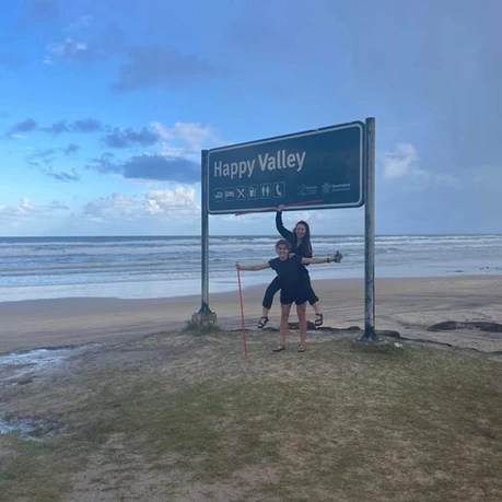
Day 7: Lake Garawongera to Happy Valley
Distance: 6.6km
Duration: 2.5hours
Final day! The last day is pretty easy walking, with some hills but lots of downhill sections. The trail starts by following the shoreline of Lake Garawongera and a climb before starting the descent. The descent comes with its own perils. It was not just steep waking down large rocks, there were huge spiders everywhere! It felt like nature was giving us a final challenge to overcome. Buoyed by the beer in our future, we pushed through the valley with one brave soul in front with a stick.
There are some ups and downs as you start to hear civilisation, and eventually we came to a crest with a power station. Here we could see out to the ocean and overlook Happy Valley. From here it was a cruisy downhill stretch into town.
We passed through the gate into the fenced area of Happy Valley (again noticing some of those Jurassic Park vibes), before checking in at our accommodation. Then it was a shower (there is a small shop where you can buy some toiletries but it’s pretty expensive) before a beer and a big meal to celebrate! It was at this juncture that we noticed a tick had latched behind an ear, and we quickly dealt with this before the celebrations could proceed. We had several beers and relived our stories from the past week, sharing what we had learned, what surprised us and where we want to adventure next.
Peaks & Pits:
PEAK: Sharing beers and stories!
PIT: Valley of the spiders.
Day 8: Final Hurrah & Heading Home
We explored the beach in the morning before the taxi picked us up around midday. The taxi drive was so fun, and I would highly recommend! We even saw a dingo while on the 4WD track, and the driver was able to share with us a lot of local knowledge after he has lived on the island for years. He dropped us to Kingfisher Resort where we spent time swimming at the beach and having some lunch at the hotel. This felt like a really fun and luxurious end to the trip. We caught a ferry in the early afternoon, and landed in River Heads from where we drove home.
Reflections: Peaks and Pits
This is a pretty epic outdoor adventure with incredible wildlife and scenery. The adventure starts from the ferry before you even arrive on the island, and you are then met with the challenge of the hike alongside navigating the wongari. This walk is somewhat challenging due to these conditions, but it is a fantastic multi-day hike between the magical rainforest, harsh bush and the chance to bask in other-worldly lakes.
K’Gari is an ode to nature at its wildest, from complex ecosystems which survive incredible conditions to the iconic wildlife. Despite the odds, huge trees and large forests grow seemingly without trouble on this sand island. Decaying plants return minerals to the sand, enabling the growth of trees and forests. As each layer of sand develops, a more complex forest system may emerge (Queensland Government, 2025). The resilience, survival and interdependent ecosystems is unique and gives some needed perspective to those of us who mainly exist in the rat race.
Seeing wongari up so close is easily one of the best nature experiences I’ve ever had, but at moments it made me feel uneasy, and that in of itself was a pretty amazing and equalising experience with nature. Dingoes in their element was truly something to behold. Do not let this scare you off visiting K’Gari or doing the walk, and while I was writing this I was umming and ahhing about how much wongari content to include. This trip is so worth doing and the wongari are not scary, but you need to be mindful of them and know how to keep them and yourselves safe.
I would highly recommend this walk, but make sure you are well-prepared for insects, wongari and volatile weather. Enjoy every chance to swim that you get!
We’re glad we brought:
- Insect repellant – think mozzies and march flies.
- A tarp – it rained a few nights and we were very thankful to be able to have a dry spot to make our meals and hang out before bed (plus leech protector during lunch!).
- Spare rope to hang up wet clothes – you will swim a lot, and hanging out the clothes in an attempt to dry them is worth the extra weight
What we’d do differently:
- I think it’s worth the money to get a taxi transfer from the ferry to start the walk from Dilli Village. Unfortunately, on the day we were starting the walk, the island taxi was booked out because of a wedding on the island. So I would suggest booking early enough so that you can book a taxi to take you from the ferry to the start of the walk (if you’re landing at Wanggoola Creek). It worked fine walking the road and side track from Wanggoolba Creek, but going from Dilli Village would be more straight forward and less risk of getting lost!
- If it’s a busy time of the year, be mindful that you will only have space in the dingo box for some food and necessities. If you want to be able to store more in the boxes, it will be 1x campsite for 2 people.
Injury Count:
- 1x tick
- Numerous leeches
- Moral injury from a spider attack
- Sunburn
- Chaffing/rashes from the salt/sand
- Blisters

Leave a comment